TheGlobe-Trotters

TheGlobe-Trotters

Sunday, September 21, 2014

The World Is A Wondrous and Strange Place

Map picture

The World Is A Wondrous and Strange Place

In my last blog I promised that when I felt better I would try to wind up writing about our trip to one of the most unusual landscapes on our planet, the Arctic Northwest. Looking back, it seems to me that there were three things of particular interests on our trip that deserve to be shared.


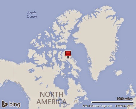
Even though after my accident I was no longer able to go ashore and could only go on deck for a very limited time, I nonetheless got to experience what the Northwest Territories of Canada were like. Our ship anchored off the town of Tuktoyaktuk, or as we called it just Tuk. This was a very important day for the Inuit Indians of this small village since it represented the very first visit ever by a cruise ship.


Not being able to go ashore to join in the festivities I did, however, stand at the rail and look across the relatively flat landscape of this environment. Dotting the landscape were large mounds which in some way reminded me of the Indian mounds you might see in Illinois. However, many of these hills were gigantic. As it turns out, I was looking at my very first Pingo.
pingo

A Pingo is a dome-shaped mound consisting of a layer of soil over a large inner core of ice. They are a striking feature to the otherwise relatively flat landscape of this terrain, and these ice cores hills are unique to permafrost areas. The region around Tuk is home to the tallest Pingo in Canada, and the second tallest in the world. It rises 160 feet into the air, or a height equal to that of a 16 story office tower. It is growing at a rate of approximately 2 cm per year, and is at least 1000 years old.


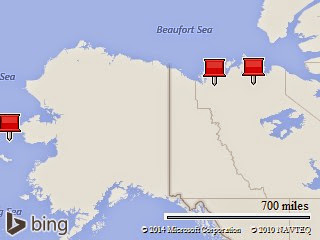
Having now been exposed to my very first Pingo, I was completely unprepared for what I was to encounter next. We came to an area that I call the "land of perpetual fire." As we cruised Westward towards the Beaufort Strait we could see a smoke filled horizon approaching. As we got closer, the smoke became more dense, and the landscape looked something like a volcanic region. What we were seeing however, had nothing to do with volcanoes. We had entered an area of Canada's Northwest territory known as the Smoking Hills. First discovered in 1826,it is a land that burns continuously, and has been doing so for centuries. The fires which burn underground, are the result of a process of autoignition between iron pyrite, sulfur and bituminous shale.IB9A7461 The landscape looked as if it was from the movie, Lord Of The Rings. I have seen elsewhere in the world where giant coal deposits have been set on fire by humans and burn for long periods of time, but I have never seen a landscape which self-ignites and burns for centuries. It was an eerie sight, and one of those unique experiences of our journey.


Lastly I would like to pass along a little bit of geographic trivia. In school I learned that the United States and Russia are at their closest points, separated by 55 miles across the Bering Strait. Well, as it turns out, that is not exactly the correct answer. Right in the middle of the Bering Strait, is a small island chain known as the Diomede Islands. The larger of the islands, known as Big Diomede, is part of Russia. The smaller island, known as Little Diomede is a part of the United States. These two islands are separated by only 2.4 miles. Even more unique, the International Date Line runs right between the two. So as we sailed directly down the Date Line, we could look to our left and see today in the United States, while if we looked to our right, we could see yesterday in Russia. See if you can figure that out?
Even though our journey was interrupted by an accident, we still were the one and only ship to transit the North West passage this year, and we got to experience some of the wonders of the Arctic North. Lisa and I have now had an opportunity to look at our photographs, and with a little help from friends who loaned us photographs towards the end of the trip, it does appear that we have enough to be able to put together another DVD to share with friends.
I hope everyone has enjoyed traveling along on this shorten trip, and know that there will be more in the future.
Jim

Tuesday, September 9, 2014

Back From The Edge


I am sitting in the lounge at the front of the ship, while all around me there is great excitement as we float on the gentle swells among the ice sheets surrounded by large herds of Walrus. Sadly as thousands of pictures are being snapped, I am confined to the inside of the ship, where all I have is my computer and no camera.

Over two weeks ago while having dinner, the ship suddenly rolled steeply over. Before I knew it, my chair tipped over and fell to the floor; and in the process severed the top of my right arm from the head of my shoulder. More critical, however, is that a portion of the bone was chipped and is now floating free. Efforts have been made to evac Lisa and me off the ship, but in the end, it was decided that it was best if we waited until our arrival into Nome on September 1st before heading home for the necessary surgery. A large part of the delay came from the remote part of the world in which we are cruising. Another big factor was the almost complete lack of communication we have had with the outside world. Since I last wrote, the ship has had no satellite connection, no phones, nor TV. Except for the emergency Iradium satellite phones carried on the bridge and by a few passengers, we have been cut-off from the outside world.

I have so much to share about an incredible journey, but for now typing is difficult. When we finally get home I will get a way setup to dictate, and then I’ll try to tell you of the wonders we have seen.

Jim

Au Canada!

Map picture

Monday August 18, 2014

Our journey west across Baffin Bay finally brought us to Pond Inlet, Nunavut, Canada. If you are at all like me, you have probably never heard of “Pond Inlet,” nor do you have any idea as to what the term “Nunavut Canada” means!

Canada is somewhat like us having a parliamentary democracy and a federation of “Provinces” analogous to our States. They also still consider themselves part of a constitutional monarchy, Great Britain. In addition to their Provinces, they also have three “territories:” The Northwest Territories, The Yukon, and the most recent territory created in 1999, Nunavut. Our journey in the northern reaches of the Canadian Artic thus begins in the Territory of Nunavut.

Pond Inlet is considered one of Northern Canada’s “Jewels of the North.” It is home to around 1,600 people, mostly Inuit. It is a “Port of Entry,” and the economy is largely based on government employment. We came ashore in our Zodiacs to a “wet” landing on to a sandy beach. We were greeted by several local guides who proceeded to provide us with a walking tour of the community. Since it was a Sunday, it was quiet, but we did get to see the town library, and eventually ended our walk at the Community Center. Here locals gave us not only a warm welcome, but also gave some moving and extremely interesting performances of Inuit traditions. Having just left the coast of Greenland, and having visited several Inuit towns along the way, it was a surprise to see just how different the Canadian village was. Gone were the “cookie cutter” homes all colorfully painted in one of five colors, and gone too were the little harbors jammed with fishing boats since here fishing is not even part of their town economy. The people here were all very friendly and everyone to whom we spoke was conversant in English – although the signage in town is generally written in the local language which is completely unintelligible to me.

The scenery of this area is simply incredible, with snowcapped mountain ranges visible on every horizon. The beautiful bay still has several floating icebergs, and one interesting fact is that when we started our trip in Greenland we were shown an “ice chart” of this area that indicated that the surface of Pond Inlet was 90% or more ice covered. By the time we had arrived here however, the ice coverage has just about disappeared. So two things to note: most of the year the waters in this beautiful part of the world are frozen over and also when the surface ice starts to breakup, it can disappear quite quickly. That is why our crew has hope for our eventually journey through the North West Passage even though still at this time, the charts are showing significant ice along our intended route.

I assume that everyone realizes that we are travelling north of the Arctic Circle, and even though it is almost September, this area still has 24 hours of light each day. That situation of course reverses, and during the winter they have 24 hours of darkness. However, for now I can look out the window of our suite and during our passage last night could witness some truly breathtaking scenery. If I were a real adventurer, I would throw on my clothes and go outside to take pictures, but sleeping somehow sounds better to me right now.

During the night and into this morning, the ship moved north to North Devon Island. This island has the distinction of being the largest uninhabited island in the world. Our journey to this remote island was to allow us to visit the remains of an old Royal Canadian Mounted Police outpost located near Dundas Harbor. The photograph which was shown last night at the briefing suggested a wet landing onto a sandy beach which was right by the outpost. However, when our zodiac pulled ashore this morning it was onto a rocky beach and before me was a steep climb up a rock strewn hill dotted with bogs that were so mushy that they threatened to literally suck my boots from my feet. Lisa had decided she was not up for going this morning, and so she had stayed on the ship which turned out to be fortunate because there is no way she could have made the trek. I was dubious, but decided to gamely climb at least to the top of the hill to see the camp, and I suspected to get some great photographs. Well, I was correct about the photographs, but to my shock, the camp itself was over the hill and down to a beach on the other side. Apparently the picture I saw last night was correct; however no one mentioned that we could not land there because of the high surf. When I reached the top soaked in sweat and looked down on the remaining hike, I just about gave up – but out of pure stupidity I gamely went on. Without question, I was the slowest of the walkers, but eventually I did reach the base and made it back to the ship all without falling. I then promptly fell asleep for two hours.

Right now the ship is cruising to an area called “Crocker Bay.” Here we will visit the last glacier on our journey, Cunningham Glacier. The plan is for all of us to be given a zodiac tour up close to the glacier and then to return to the ship in time for dinner.

Let me share a couple of quick points. First, the ship has been without either cell phone service or internet for several days. Everyone was hoping that when we visited Pond Inlet yesterday that we would at least have cell phone coverage, but no one could connect. That seems strange since during our welcome it was mentioned that the town was proud of its new cell service, but none of us could connect to the network. We have a few passengers who are carrying their own satellite phones, and I understand that even they are having some difficulty in making calls. I know the ship itself is getting some communication over the iridium system, but for us for now; we are not connected, which this day and age feels strange.

Finally we have reached the area where the polar bears live. Starting today and from now on, before we are allowed off the ship a complete survey is made of our landing area to insure that it is free of bears. While we are off the ship, there are “bear guides” on our perimeter to sound any alerts should bears appear. If they do appear, then we must all return to the ship. We will probably see polar bears, but we will see them from the safety of the ship or from a Zodiac.

Lisa and I hope that everyone is well. I should remind you that when I write an e-mail at the same time I will post it on our web page where it will have a map and usually some pictures. You can reach that page by going to theglobe-trotters.com

Also if you just would like to see some pictures from the trip then you can jump directly to the by going to https://picasaweb.google.com/jstevens10

Jim

Greenland Equals Ice


Saturday August 16, 2014

It is hard to believe that we have been on our cruise now for a full week. As you recall, because of the ice situation in Canada, we have spent this entire time travelling north along the west coast of Greenland while waiting for conditions to improve along our route through the North West Passage. At this time, conditions while improved are still not favorable enough to insure that we will be able to make the passage, but the decision has been made to leave Greenland behind and to travel to our first stop in Canada, Pond Inlet. The distance to be covered is around 450 miles and will take us about a day and a half. Right now we are therefore cruising west, across what is known as Baffin Bay, and are scheduled to arrive at our port tomorrow about noon.

I wrote to you last on August 12th; at that time, we had spent the night at anchor off the coast from Ilulissat with the hope that the morning weather conditions would improve and allow us to visit this community. They did not improve, and instead we went north to the village of Saqqaq. Over the next several days, our ship explored the coast northward, stopping at several local communities with names I cannot pronounce. We even visited a rather large mining community, but the mine had shut down and was abandoned; we stopped at a place called Qllakitsoq, where in 1972, extremely well preserved mummies were found dating from the 1300’s; and eventually, we reached our northernmost point yesterday, at the community of Upernavik, which is home to around 1,200 people. It is located at 72’ North and 56’ West.

All along our journey we have been surrounded by magnificent scenery and breathtaking icebergs of all shapes and sizes. In fact, I recall on our first day when an iceberg appeared there was jubilation all over the ship, and there was a mad dash to the upper decks to take pictures. Now if you look outside and see “another” iceberg, it is a rather “ho-hum” matter because they are so common now.

Rather than trying to present a running dialogue of each day’s activities, I wanted to step back and look at a somewhat larger picture. In truth, every village we visited had a familiar feeling to it, looking just like the last village we visited. While the typical village or community in Greenland is quite colorful, they only use about five colors to paint their houses and buildings. Since 81% of Greenland is ice, the remaining land lies along the coasts and is a narrow, mountainous, barren and rocky terrain. Believe it or not, Greenland is shown as having 0% arable land, and likewise 0% permanent crops. So each little village, while colorful, seems to cling precariously to the steep rocky terrain. While Greenland is the 12th largest country by landmass, it is home to only 53,000 people. Those small numbers of people are confined to a narrow band of rocky land along the immense shoreline of Greenland where they live in very small communities. The population of Greenland is 89% Inuit, and without question the main source of income is fishing. I wondered just how these small communities could afford to support themselves on fishing alone, particularly when you realize that in winter the sea freezes over and they must use dog sleds to go out on the ice, cut holes, and fish using long baited lines. This is certainly not a large scale operation. Well it seems that Greenland receives large subsidies from Denmark. That is how Air Greenland can afford to operate to these small villages; it is how cellular and internet service is available; and it is where young people go if they want to receive a higher education.

So, I am very thankful for our additional time in Greenland. It has certainly given me a better understanding of this large and exciting land. Now, however, we move west to Canada where we hope we will find a way to make the North West Passage. Every evening we are privileged to receive a briefing on what is coming up. That briefing has included detailed ice charts of our planned passage with a frank discussion of what is happening. I learned something very interesting. The ice chart is not showing the thickness of the sea ice, but rather the percentage of the surface covered by ice. Whereas an icebreaker is designed to “ride up on” the ice sheet, and crush it thus creating a passage. We are in a vessel with an ice hardened hull, where we can “push ice aside” as we go, but that implies that we have somewhere to push the ice. If the ice sheet is solid, then as I witnessed once on this very ship in Antarctica, the ship will go only so far before becoming unable to go further – there is no place to push through. Right now our passage forward is blocked by solid ice sheets, but we are still at least five days away from confronting that issue, and the leadership seems to feel confident that by then the situation will improve. This should be a fascinating experience, and one that I am anxious to share, after all “What a Wonderful World.”

Jim

PS Right now we do not have internet service, and so I will be careful to date my musings so that when I can send them, it will make some sense.